92 Trinity BoulevardAttwood VIC 3049
Property Details for 92 Trinity Bvd, Attwood
Last Listing description (February 2025)
Nestled within the highly sought-after boutique estate of Cambridge Gardens, this rare vacant land of 653m offers the perfect canvas to create your dream home. With a generous 19m frontage and a mainly rectangular layout, this easement-free parcel maximizes your building possibilitiesideal for a range of design options.
Enjoy the serenity and beauty of the Moonee Pond Creek trails right on your doorstep, leading to the expansive Woodlands Historic Park. This idyllic location offers an unbeatable lifestyle, with the vibrant Westmeadows Village just moments away for your shopping, dining, and entertainment needs. Plus, the convenience of nearby public transport, schools, sporting ovals, Melbourne Airport, and quick access to the Tullamarine Freeway makes it the perfect place to live, work, and play.
This is a rare opportunity to secure land in one of Attwood's most desirable estates. Enquire today and begin planning your dream home!
Property History for 92 Trinity Bvd, Attwood, VIC 3049
- 18 Feb 2025Sold
- 07 Nov 2024Listed for Sale $750,000-$800,000
- 20 Feb 2015Sold for $340,000
Recent sales nearby
See more recent sales nearbySimilar properties For Sale nearby
See more properties for sale nearby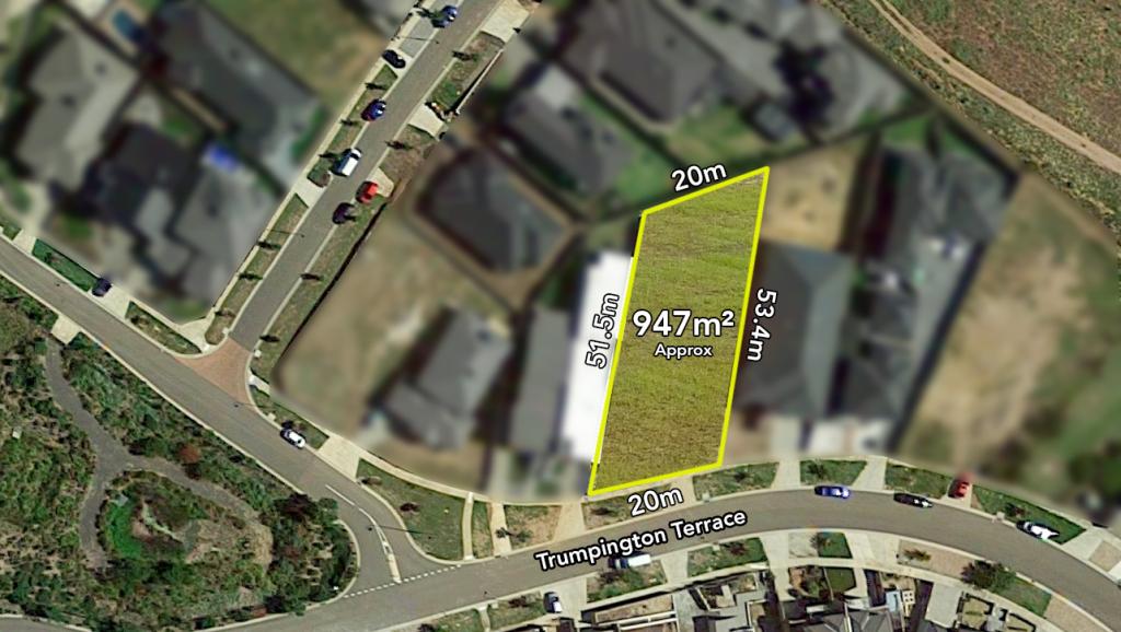

Similar properties For Rent nearby
See more properties for rent nearby
About Attwood 3049
The size of Attwood is approximately 5 square kilometres. It has 8 parks covering nearly 8.3% of total area. The population of Attwood in 2011 was 3,260 people. By 2016 the population was 3,427 showing a population growth of 5.1% in the area during that time. The predominant age group in Attwood is 50-59 years. Households in Attwood are primarily couples with children and are likely to be repaying $1800 - $2399 per month on mortgage repayments. In general, people in Attwood work in a clerical occupation. In 2011, 88.5% of the homes in Attwood were owner-occupied compared with 87.4% in 2016.
Attwood has 1,199 properties. Over the last 5 years, Houses in Attwood have seen a 15.94% increase in median value, while Units have seen a 18.58% increase. As at 28 February 2025:
- The median value for Houses in Attwood is $826,190 while the median value for Units is $573,548.
- Houses have a median rent of $650.
What's around 92 Trinity Bvd, Attwood
92 Trinity Bvd, Attwood is in the school catchment zone for Westmeadows Primary School and Gladstone Park Secondary College.


Suburb Insights for Attwood 3049
Market Insights
Attwood Trends for Houses
$826k
0.16%
View Trend$650/W
3.94%
Attwood Trends for Units
$574k
6.04%
View TrendN/A
4.83%
Neighbourhood Insights
Age
Population 3,427
0-9
11%
10-19
17%
20-29
14%
30-39
9%
40-49
17%
50-59
18%
60-69
9%
70-79
4%
80-89
2%
Household Structure
Occupancy
© Copyright 2025 RP Data Pty Ltd trading as CoreLogic Asia Pacific (CoreLogic). All rights reserved.
This product uses cookies and other similar technologies to improve and customise your browsing experience, to tailor content and adverts, and for analytics and metrics regarding visitor usage on this product and other media. We may share cookie and analytics information with third parties for the purposes of advertising. By continuing to use our website, you consent to cookies being used. View our Privacy Policy here.
X