1/160 Sand Marsh RoadWoodsdale TAS 7120
Property Details for 1/160 Sand Marsh Rd, Woodsdale
Last Listing description (April 2024)
Within commuting distance of the Hobart CBD and/or the popular Tasmanian East Coast township of Orford, a part of 160 Sand Marsh Road, Woodsdale offers plenty of options as recreational weekend bush block, conservation holding or a small scale forestry operation. Set within the foothills of Mount Hobbs and Tiger Hill the property offers the following:
Holding:
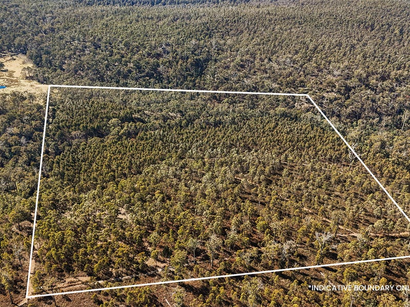
Surrounded by State Forest, this 20.25ha (50.0 acres) holding offers approximately 7.5ha of Tasmanian Eucalyptus Nitens plantation with the remaining 12.75 ha native Tasmanian bushland of species traditionally found on the Tasmanian East Coast. These include Eucalyptus such as Peppermint, White Gum, White-Top and Swamp-Gum with a bracken fern under-storey. A water course known as Cat Gut Gully flows through the north eastern corner of the holding.
An access track circuits the perimeter and middle of the property offering easy access for exploring the property.
The property offers a grey-brown sandy loam base with an average rainfall of 516mm annually.
Area:
Settled in 1875, Woodsdale was named by the then inspector of roads Mr. N.A. Woods, who laid out the road from Whitefoord to Buckland.
Free settlers in the 1860s to 1890's took-up land grants in the area and transformed the area into the one of the best mixed farming area in the Oatlands district. Similar activities are maintained to this present day in the district with beef, lamb and forestry as the main agricultural pursuits. Australia Post collection is available at nearby Buckland.
This property is 15-minutes drive to Buckland, 30-minutes drive to the East Coast holiday township of Orford and a little over one hour to the Hobart CBD (via Tasman Highway).
A part of 160 Sand Marsh Road, Woodsdale offers plenty of options for the recreational weekend bush block, conservation holding or a small scale forestry operation.
Facts:
Title Reference: Vol 118556/1
Land Size: 20.25 ha (50.0 acres)
Zoning: Rural.
Council: Southern Midlands Council.
Howell Property Group has no reason to doubt the accuracy of the information in this document which has been sourced from means which are considered reliable, however we cannot guarantee its validity. Prospective clients are advised to carry out their own investigations.
Property History for 1/160 Sand Marsh Rd, Woodsdale, TAS 7120
- 04 Oct 2023Listed for Sale Contact Agent
Commute Calculator
About Woodsdale 7120
The size of Woodsdale is approximately 94.6 square kilometres. It has 2 parks covering nearly 45.3% of total area. The population of Woodsdale in 2011 was 328 people. By 2016 the population was 79 showing a population decline of 75.9% in the area during that time. The predominant age group in Woodsdale is 60-69 years. Households in Woodsdale are primarily childless couples and are likely to be repaying $800 - $999 per month on mortgage repayments. In general, people in Woodsdale work in a managers occupation. In 2011, 78.3% of the homes in Woodsdale were owner-occupied compared with 83.8% in 2016..
Woodsdale has 75 properties. Over the last 5 years, Houses in Woodsdale have seen a 90.97% increase in median value. As at 31 October 2024:
- The median value for Houses in Woodsdale is $529,890.
Suburb Insights for Woodsdale 7120
Market Insights
Woodsdale Trends for Houses
N/A
N/A
View TrendN/A
N/A
Woodsdale Trends for Units
N/A
N/A
View TrendN/A
N/A
Neighbourhood Insights
© Copyright 2024 RP Data Pty Ltd trading as CoreLogic Asia Pacific (CoreLogic). All rights reserved.

 0
0

