58 Ellis RoadWallaroo SA 5556
Property Details for 58 Ellis Rd, Wallaroo
58 Ellis Rd, Wallaroo is a 3 bedroom, 2 bathroom House and was built in 2021. The property has a land size of 10000m2 and floor size of 126m2. While the property is not currently for sale or for rent, it was last sold in December 2024. There are 55 other 3 bedroom Houses sold in Wallaroo in the last 12 months.
Last Listing description (December 2024)
Situated on approximately 2.5 Acres, this stunning newly constructed home is a true gem, offering a modern and stylish living experience. This Wahlstedt Quality Home was built in 2021 and is perfect for families or retirees seeking extra space. The interior design is impeccable, featuring high-quality finishes and fixtures throughout.
The master bedroom features a large en-suite with a huge shower, all 3 bedrooms are a good size, featuring vinyl planks, built in wardrobes and quality blinds.
The centre of the home is an open plan living area, the kitchen is bright and offers an island bench, a large gas cooktop and dishwasher. The living area has room for the largest of dining tables and spacious lounge with down lights and ducted reverse cycle air conditioning so you can stay comfortable all year round.
Outside offers a Solar System, 67,500L of rainwater which is connected to the home, an Enviro-cycle water treatment system (all household water treated and re-used on gardens and lawns) and fenced on 3 sides. For more information call Sales Agent Shaun Miller on 0407 957 082.
Property History for 58 Ellis Rd, Wallaroo, SA 5556
- 16 Dec 2024Sold for $653,000
- 13 Sep 2024Listed for Sale $675,000
- 07 Dec 2015Sold for $110,000
Recent sales nearby
See more recent sales nearby
Similar properties For Sale nearby
See more properties for sale nearby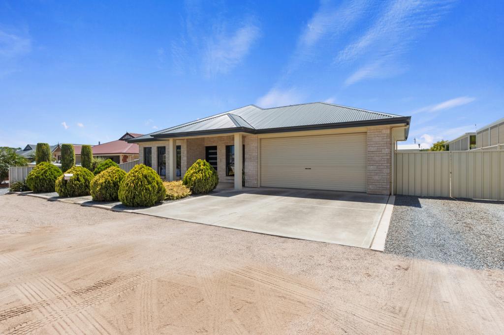
About Wallaroo 5556
The size of Wallaroo is approximately 48.2 square kilometres. It has 30 parks covering nearly 2.6% of total area. The population of Wallaroo in 2011 was 3,225 people. By 2016 the population was 3,462 showing a population growth of 7.3% in the area during that time. The predominant age group in Wallaroo is 60-69 years. Households in Wallaroo are primarily childless couples and are likely to be repaying $1000 - $1399 per month on mortgage repayments. In general, people in Wallaroo work in a labourer occupation. In 2011, 64.3% of the homes in Wallaroo were owner-occupied compared with 61.3% in 2016.
Wallaroo has 3,533 properties. Over the last 5 years, Houses in Wallaroo have seen a 100.25% increase in median value, while Units have seen a 82.48% increase. As at 28 February 2025:
- The median value for Houses in Wallaroo is $467,976 while the median value for Units is $407,424.
- Houses have a median rent of $383 while Units have a median rent of $200.
What's around 58 Ellis Rd, Wallaroo


Suburb Insights for Wallaroo 5556
Market Insights
Wallaroo Trends for Houses
$468k
18.13%
View Trend$382.5/W
4.54%
Wallaroo Trends for Units
$407k
2.06%
View TrendN/A
4.03%
Neighbourhood Insights
Age
Population 3,462
0-9
9%
10-19
9%
20-29
8%
30-39
9%
40-49
10%
50-59
16%
60-69
19%
70-79
14%
80-89
5%
90-99
1%
Household Structure
Occupancy
© Copyright 2025 RP Data Pty Ltd trading as CoreLogic Asia Pacific (CoreLogic). All rights reserved.
This product uses cookies and other similar technologies to improve and customise your browsing experience, to tailor content and adverts, and for analytics and metrics regarding visitor usage on this product and other media. We may share cookie and analytics information with third parties for the purposes of advertising. By continuing to use our website, you consent to cookies being used. View our Privacy Policy here.
X