537 Bellmere RoadWaraba QLD 4513
Property Details for 537 Bellmere Rd, Waraba
Last Listing description (May 2024)
* LARGE ACRE DEVELOPMENT SITE DIRECTLY OPPOSITE THE NEW PROPOSED TOWN CENTRE
* 12 SCHOOLS, A HOSPITAL, 7 NEW SUBURBS & 6 NEIGHBOURHOOD HUBS
* 106HA OF TOWN CENTRE, COMMERCIAL & INDUSTRIAL AREAS DESIGNATED FOR THE AREA
Caboolture West is the only major location north of Brisbane designated in the South East Queensland Regional Plan for the regions next major residential community. The State Government has just signed off on the Master Plan on 11th August 2017 with West Caboolture being 1 of only 4 Major Expansion Areas in the whole of South East Queensland. The long wait is now over and developers are on the cusp of and a major step forward to begin to start developing this exciting new township that is anticipated to accommodate up to 70,000 new residents. The area will include up to seven new suburbs, three high schools, nine primary schools and new commercial and industrial areas. The net benefit to the community from the development is expected to be in excess of $10 billion. The area, detailed in Moreton Bay Regional Councils draft planning scheme, covers 3173 hectares between Caboolture and Morayfield, and the foothills of Mt Mee.
Key Infrastructure is inclusive of -
A 106 ha town centre, 12 schools, a hospital and a public transport corridor to Caboolture station.
Each of the 13 neighbourhood hubs, all within a 400m or five-minute walk of homes, would have housing to accommodate up to 70,000 new residents with 1070 hectares dedicated to green corridor networks.
Convenience retail, commercial and community uses as well of course the huge town centre. This whole master plan is predicted to be more than twice the size of North Lakes.
About 160ha, or 9 per cent of the area, would be for industrial or commercial uses as part of the goal to create 17,000 jobs in the Caboolture West area.
There will also be provision for a rapid transit corridor linking the town centre, located on Bellmere Rd west of Stern Rd, to the Caboolture CBD.
Key developers have bought up in the area and have land banked to get ready for what will be a major Queensland development. This parcel of residential land zoned "Urban Living-Emerging Community" is in a prime position given its proximity to the proposed Town Centre hub and its surrounds. The diversity and beauty of this area has to been seen to be believed. With its lush valleys, rivers and mountain views but then being only a short drive to all infrastructure, the Bruce Highway, Brisbane and the Sunshine Coast. It ticks all the boxes but the areas beauty will make this town and the residential blocks available highly sought after.
NOW IS THE TIME TO GET A FOOTHOLD IN THIS AREA!!! EDIT TEXT
Property History for 537 Bellmere Rd, Waraba, QLD 4513
- 17 May 2024Listed for Sale EXPRESSION OF INTEREST
- 31 Jan 2018Listed for Sale EXPRESSION OF INTEREST
Commute Calculator
Recent sales nearby
See more recent sales nearby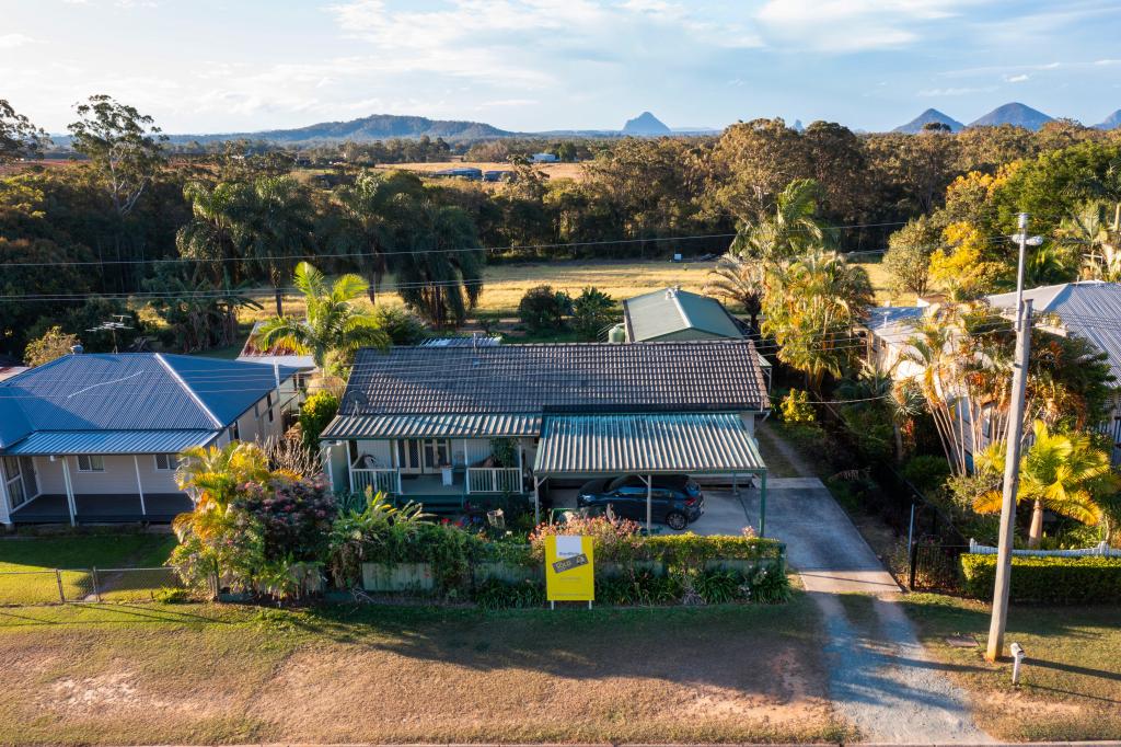 0
0
Similar properties For Sale nearby
See more properties for sale nearby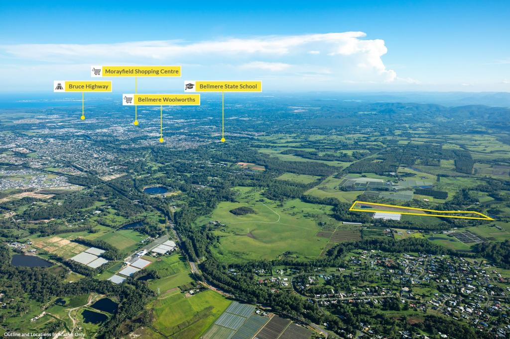 0
0 0
0About Waraba 4513
The size of Waraba is approximately 23.7 square kilometres. It has 13 parks covering nearly 2% of total area. The population of Waraba in 2011 was 5,540 people. By 2016 the population was 5,863 showing a population growth of 5.8% in the area during that time. The predominant age group in Waraba is 0-9 years. Households in Waraba are primarily couples with children and are likely to be repaying $1800 - $2399 per month on mortgage repayments. In general, people in Waraba work in a labourer occupation. In 2011, 56% of the homes in Waraba were owner-occupied compared with 55.5% in 2016..
Waraba has 3 properties.
Suburb Insights for Waraba 4513
Market Insights
Trends for Houses
N/A
N/A
View TrendN/A
N/A
Trends for Units
N/A
N/A
View TrendN/A
N/A
Neighbourhood Insights
© Copyright 2024 RP Data Pty Ltd trading as CoreLogic Asia Pacific (CoreLogic). All rights reserved.
This product uses cookies and other similar technologies to improve and customise your browsing experience, to tailor content and adverts, and for analytics and metrics regarding visitor usage on this product and other media. We may share cookie and analytics information with third parties for the purposes of advertising. By continuing to use our website, you consent to cookies being used. View our Privacy Policy here.
X