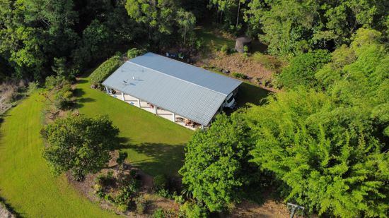
53 Sandy Pocket RoadSandy Pocket QLD 4871
Property Details for 53 Sandy Pocket Rd, Sandy Pocket
Last Listing description (May 2020)
This 2.93 ha (7.2 acres) property is located on quiet Sandy Pocket Road just off the Bruce Highway and approximately 18 kilometres south of the regional centre of Innisfail and 100 kilometres south of Cairns. The land is flat and all usable and comprises rich river loam soils. An extra bonus is the permanent creek flowing along the southern boundary.
Property History for 53 Sandy Pocket Rd, Sandy Pocket, QLD 4871
- 03 Feb 2022Sold for $100,000
- 19 Mar 2020Sold for $80,000
- 18 Dec 2018Listed for Sale $150,000
Commute Calculator
About Sandy Pocket 4871
The size of Sandy Pocket is approximately 5.3 square kilometres. It has 1 park covering nearly 1.6% of total area. The population of Sandy Pocket in 2011 was 219 people. By 2016 the population was 23 showing a population decline of 89.5% in the area during that time. The predominant age group in Sandy Pocket is 50-59 years. Households in Sandy Pocket are primarily childless couples and are likely to be repaying $1000 - $1399 per month on mortgage repayments. In general, people in Sandy Pocket work in a managers occupation. In 2011, 73.3% of the homes in Sandy Pocket were owner-occupied compared with 63.7% in 2016..
Sandy Pocket has 25 properties. As at 30 November 2024:
- The median value for Houses in Sandy Pocket is $672,672.
Suburb Insights for Sandy Pocket 4871
Market Insights
Sandy Pocket Trends for Houses
N/A
N/A
View TrendN/A
N/A
Sandy Pocket Trends for Units
N/A
N/A
View TrendN/A
N/A
Neighbourhood Insights
© Copyright 2024 RP Data Pty Ltd trading as CoreLogic Asia Pacific (CoreLogic). All rights reserved.

 0
0

