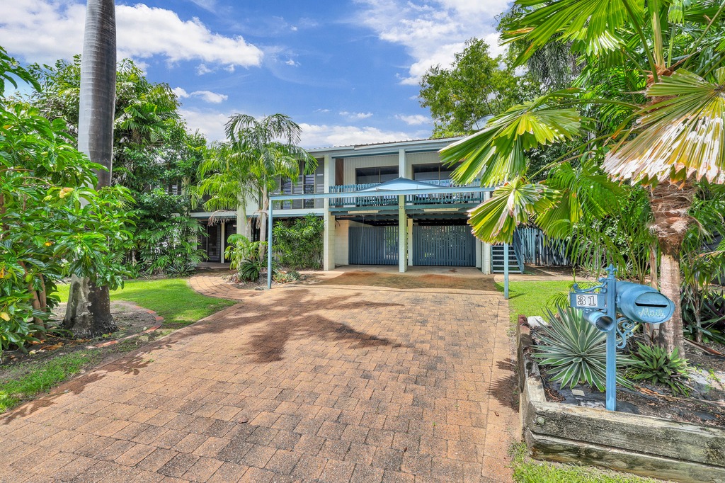
9 Shady Court, Leanyer, NT 0812 | Property Value & History | OnTheHouse
OFF MARKET
Are you the owner?

9 Shady Court
Leanyer NT 0812

Bedrooms: 3
Bathrooms: 1
Car spaces: 2
Floor area: 100m2
Land area: 970m2
Estimated Value & Rent
Estimated Value
Estimated Rent
Medium-High Confidence
Last updated 31 Mar 2025
Low

High
$500k
$550k
Save

Property Details for 9 Shady Ct, Leanyer

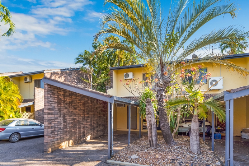
9 Shady Ct, Leanyer is a 3 bedroom, 1 bathroom House with 2 parking spaces and was built in 1980. The property has a land size of 970m2 and floor size of 100m2. While the property is not currently for sale or for rent, it was last sold in October 2021.

Building Type
House
Year Built
1980
Floor Size
100m2
Land Size
970m2
Local Government
Darwin
Lot/Plan
Loc 685 Lot 4342/S 80/046B

Last Listing description (November 2021)

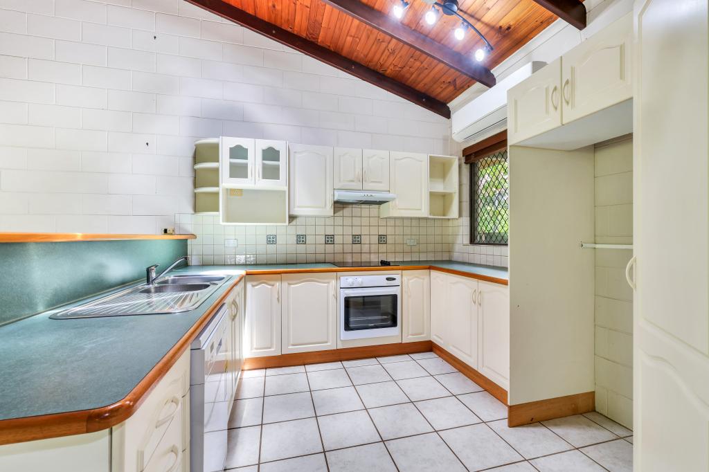
This lovely ground level home is as neat as they come and is set in a quiet cul de sac of similar homes. Recently made over its a property you could just move right in and enjoy. With an updated kitchen and renovated bathroom it means you don't have to spend anything but your purchase price. Set on a larger than average block of 942m2 it offers a big open backyard for the kids to enjoy. Built off the rear of the home is a shady verandah area which would be just the spot to enjoy a quiet drink with friends or family. a sturdy garden shed is also provided to cater for the garden gear and camping items.
Set in quiet cul de sac location
Freshly renovated bathroom and upgraded kitchen

Ground level solidly constructed family home
Fully tiled throughout
Shady rear verandah
Large open block with big backyard
Motivated vendor wants sale

Property History for 9 Shady Ct, Leanyer, NT 0812

A timeline of how this property has performed in the market
Last Sold
$475,000
29 Oct 2021
Listed for Rent
$400/w
07 Nov 2009
  • 29 Oct 2021
    Sold for $475,000
  • 22 Jun 2021
    Listed for Sale $495,000
  • 23 Feb 2015
    Sold for $500,000
Sign in to see more transactions

Commute Calculator

Where to?
-
-
-
-

About Leanyer 0812

The size of Leanyer is approximately 5.9 square kilometres. It has 14 parks covering nearly 59.3% of total area. The population of Leanyer in 2011 was 4,691 people. By 2016 the population was 4,608 showing a population decline of 1.8% in the area during that time. The predominant age group in Leanyer is 30-39 years. Households in Leanyer are primarily couples with children and are likely to be repaying $1800 - $2399 per month on mortgage repayments. In general, people in Leanyer work in a professional occupation. In 2011, 62.2% of the homes in Leanyer were owner-occupied compared with 60.3% in 2016.

Leanyer has 1,902 properties. Over the last 5 years, Houses in Leanyer have seen a 28.66% increase in median value, while Units have seen a 34.30% increase. As at 31 March 2025:

  • The median value for Houses in Leanyer is $610,114 while the median value for Units is $332,135.
  • Houses have a median rent of $650 while Units have a median rent of $530.
There are currently 4 properties listed for sale, and 3 properties listed for rent in Leanyer on OnTheHouse. According to CoreLogic's data, 100 properties were sold in the past 12 months in Leanyer.

What's around 9 Shady Ct, Leanyer

Nearby Schools
Comparable Properties
Leanyer Primary School
0.58km
Leanyer 0812
PrimaryGovernmentP - 6Combined510 Enrolled
St Andrew Lutheran School
0.74km
Leanyer 0812
PrimaryNon-GovernmentCombined111 Enrolled
Good Shepherd Lutheran College - St Andrews Campus
0.74km
Leanyer 0812
PrimaryNon-GovernmentCombined Enrolled
Wulagi Primary School
1.2km
Wulagi 0812
PrimaryGovernmentP - 6Combined204 Enrolled
Sanderson Middle School
1.26km
Malak 0812
SecondaryGovernment7 - 9Combined388 Enrolled
Malak Primary School
1.6km
Malak 0812
PrimaryGovernmentP - 6Combined211 Enrolled
O'Loughlin Catholic College
1.91km
Karama 0812
SecondaryNon-Government7 - 12Combined568 Enrolled
Anula Primary School
1.94km
Anula 0812
PrimaryGovernmentP - 6Combined386 Enrolled
Holy Family Catholic Primary School
1.97km
Karama 0812
PrimaryNon-GovernmentP - 6Combined234 Enrolled
Wanguri Primary School
2.03km
Wanguri 0810
PrimaryGovernmentP - 6Combined311 Enrolled

Suburb Insights for Leanyer 0812

Market Insights
Leanyer Trends for Houses
Median Value

N/A

-
View Trend
Median Growth

N/A

View Trend
Median Rent

N/A

-
View Trend
Rental Yield

N/A

-
View Trend
Median Value: The middle value of all properties across the geography based on the Automated Valuation Model.


Median Value over 1 year
Leanyer Trends for Units
Median Value

N/A

-
View Trend
Median Growth

N/A

View Trend
Median Rent

N/A

-
View Trend
Rental Yield

N/A

-
View Trend
Median Value: The middle value of all properties across the geography based on the Automated Valuation Model.


Median Value over 1 year
Neighbourhood Insights
Age

Population 4,608

0-9


14%

10-19


12%

20-29


13%

30-39


16%

40-49


15%

50-59


16%

60-69


10%

70-79


5%

80-89


1%

Household Structure
Occupancy
Disclaimer
Whilst all reasonable effort is made to ensure the information in this publication is current, CoreLogic does not warrant the accuracy or completeness of the data and information contained in this publication and to the full extent not prohibited by law excludes all liability for any loss or damage arising in connection with the data and information contained in this publication.
Valuations and Estimates
This estimate is provided by CoreLogic, and is based on statistical market data such as recent local sales, property size, number of bedrooms and many more factors. It comes from public data, which may be incomplete or inaccurate, and should not be used in lieu of a professional appraisal under any circumstances, including for lending purposes or in home loan applications.
School data and Content
Product Data licenced by CoreLogic under a Creative Commons Attribution licence. For details regarding licence, data source, copyright and disclaimers, see https://www.corelogic.com.au/legals/third-party-restrictions
ABS data
This publication contains data and statistics provided by the Australian Bureau of Statistics, available at http://www.abs.gov.au/ and reproduced under Creative Commons Attribution 2.5 http://creativecommons.org/licenses/by/2.5/au/legalcode
Liveability information
The Liveability Score is a rating (out of 10) provided by Propella.ai Pty Ltd as a guide about how "well-connected" properties are in certain local areas. The Liveability Score is based on statistical data about a local area in which a property is located including the distance to and number of available facilities and services (including schools, parklands, health services, shopping and public transport) (Liveability Data). The Liveability Data and Liveability Score has not been verified or confirmed by CoreLogic, is not available for all properties, and is of a general nature and should not be construed as specific advice or relied upon in lieu of appropriate professional advice. Given the relative nature of the Liveability Score, propella.ai anticipate that scores for individual properties will change over time.