17 Wirreanda RoadIngleside NSW 2101
Property Details for 17 Wirreanda Rd, Ingleside
Last Listing description (November 2021)
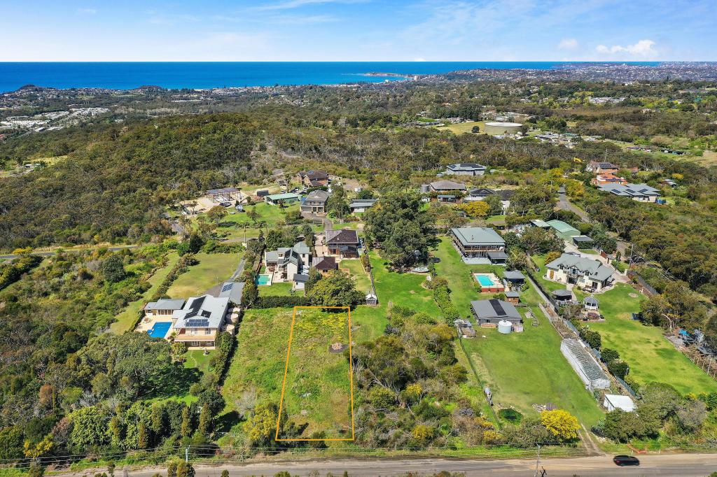
A slice of rural beauty to build your dreams on. It could be the site for your stunning custom-built home, set in peaceful country surroundings. On the other hand, it could be a perfect place to make your new business venture a reality. With approx 37,000m2 to play with, inspiration is seemingly endless.
Land opportunities of this scale appear very rarely in such a sought after area. A beautiful deep rectangular lot, the land virtually backs onto Ku-ring-gai National Park and the charming Wirreanda Creek runs parallel to its perimeter. Gently sloping to the creek, the parcel is predominantly level and has a large cleared area in the centre, extending to the rear. Natural bushland is established at both the front and back border of the property. The ambience is extremely peaceful, with the address being ideally set back from Mona Vale Road to ensure a lovely sense of quietness.
Whilst feeling a world away in the countryside, you are conveniently located to major shopping precincts. Thriving Mona Vale village with fabulous shopping and dining is a short 12 minute drive east and St Ives Village is only a few minutes more in the opposite direction. You will also find yourself in close proximity to a wealth of other services. Neighbouring Terrey Hills has excellent garden centres and the vibrant Terrey Hills Tavern. Belrose Supa Centre and Bunnings are less than 10 minutes away.
Nature walk and scenic picnic opportunities are easily accessible with the entrance to stunning Ku-ring-gai National Park a short drive down McCarrs Creek Road. When you feel like keeping the car parked, additional walks through surrounding bushland are at your doorstep off Wirreanda Rd itself.
Whilst the block can't be divided up for development, a broad spectrum of business activities are permitted with consent. A single occupancy home is allowed alongside business premises outlined below (STCA);
Agricultural produce industry, agriculture
Animal boarding and training establishments
Aquaculture
Bed and breakfast accommodation
Bay caping
Centre based childcare facility
Community facility
Dairy pasture without consent
Dairy restricted with consent.
Environmental facility
Extensive agriculture so stop farm build
Disclaimer: We have obtained all information in this document from sources we believe to be reliable; however, we cannot guarantee its accuracy. Prospective purchasers are advised to carry out their own investigations
Property History for 17 Wirreanda Rd, Ingleside, NSW 2101
- 03 Dec 2021Sold for $6,570,000
- 03 Nov 2021Listed for Sale Auction Guide $2,750,000
Commute Calculator
Recent sales nearby
See more recent sales nearbySimilar properties For Sale nearby
See more properties for sale nearbyAbout Ingleside 2101
The size of Ingleside is approximately 18.2 square kilometres. It has 14 parks covering nearly 59.4% of total area. The population of Ingleside in 2011 was 1,122 people. By 2016 the population was 976 showing a population decline of 13.0% in the area during that time. The predominant age group in Ingleside is 50-59 years. Households in Ingleside are primarily couples with children and are likely to be repaying over $4000 per month on mortgage repayments. In general, people in Ingleside work in a trades occupation. In 2011, 68% of the homes in Ingleside were owner-occupied compared with 69.5% in 2016.
Ingleside has 492 properties. Over the last 5 years, Houses in Ingleside have seen a 37.90% increase in median value, while Units have seen a 27.50% increase. As at 31 October 2024:
- The median value for Houses in Ingleside is $3,429,778 while the median value for Units is $1,573,900.
- Houses have a median rent of $975.
Suburb Insights for Ingleside 2101
Market Insights
Ingleside Trends for Houses
N/A
N/A
View TrendN/A
N/A
Ingleside Trends for Units
N/A
N/A
View TrendN/A
N/A
Neighbourhood Insights
© Copyright 2024 RP Data Pty Ltd trading as CoreLogic Asia Pacific (CoreLogic). All rights reserved.

/assets/perm/ke63ko54gei6xkpfk52c4iisva?signature=47377dc334b7904b90530848c58bc355bec7190d13a05a84dfe2ae3fad683f37) 0
0/assets/perm/3urwgxa6eei6xewfiefyccpnoe?signature=4e40037de6ff30436a842cb2b97e36ff938b553817ed8510a9bc482dbcd7d325) 0
0/assets/perm/mannb22ruai6zicueexmobyvrq?signature=7563a08a09dae1aca0a9e1069982cf1f2af984c324518e88697ebd92f044e6d0) 0
0 0
0

 0
0
 0
0


